![]()
Search:
• Sites
• Bags
• Architecture
• Objects
• Ceramics
• Inscriptions
• Drawings
• Maps
• Photographs
MHAS Database
This is the online database of the Middle Hadramawt Archaeological Survey (MHAS). The primary purpose of this site is to provide easy access to the project data by scholars collaborating on different aspects of the survey. A secondary goal of this website is to showcase a database front end that can be easily adapted to other archaeological work.
The Middle Hadramawt Archaeological Survey is the fieldwork component of Paul Zimmerman’s doctoral dissertation at the University of Pennsylvania. It is a catalog of archaeological sites in the Wadi Hadramawt, Yemen, between the cities of Qatn and Tarim, including tributary wadis. It is hoped that this documentation will benefit the Yemeni archaeological authorities in protecting their cultural heritage, and will improve our understanding of how and why settlement of the wadi changed through time.
Map of Yemen, Showing the MHAS Study Area: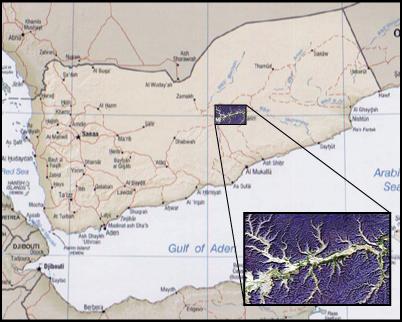 |
Dissertation: • Zimmerman Dissertation (2008) MHAS Field Reports: • 1997 GOAMM Report • 1999 GOAMM Report • 2001 GOAMM Report • 2004 GOAM Report MHAS Project Data: • MHAS Database SQL Dump (MySQL) Maps and GIS Resources: • magellan2grass.awk Data Parser • Single-page Map of the Wadi Hadramawt • 50m Contour Map of the Wadi Hadramawt (1:100,000 scale) • Google Earth KMZ file of MHAS sites and coverage |
Feel free to browse this site by clicking on one of the links to the left. In order to properly display transliterated characters, you may need to install a special font such as Gentium, which is freely downloadable from SIL International. If you have any questions or comments, please don’t hesitate to email Paul Zimmerman directly.